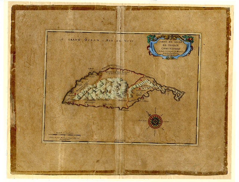
| Creator: | Nicholas Sanson, (1600-1667), cartographer |
|---|---|
| Abraham Peyrounin, (1620-1666), engraver | |
| Title: | Carte de Isle de Sainct Christophle |
| Publication | chez Mariette (A Paris), 1656 |
| Description | engraved and hand tinted map, 42 x 49 cm |
| Scale | [ca.1:114,000] |
| Notes: | |
| Shelf Mark: | VCSK/01 |

| Creator: | Andrew Norwood (1623-1686) John Thornton (1641-1708) |
|---|---|
| Title: | A new Mapp of the Island of St Christophers, being anactuall Survey taken by Andrew Norwood, Surveyor-General. New Map of the Island of Guardalupa. ; New Map of the Island of Martineca. |
| Publication: | London: [1780] sold by W Mount and T Page in Tower Hill |
| Description: | Atlas maritimus or, the sea-atlas : being a book of maratime (sic) charts describing the coasts, capes, headlands, sands, shoals, rocks and dangers, the bays, roads, harbours, rivers, and ports in most of the known parts of the world : with the true course and distances from one place to anot., gathered from the latest discoveries that hath been made, by divers[e], able and experienced navigators of our English nation, accommodated with an hidrographical (sic) description of the whole world &c. |
| Scale: | [1:71,000] |
| Notes: | |
| Shelf Mark: | VCSK/02 |
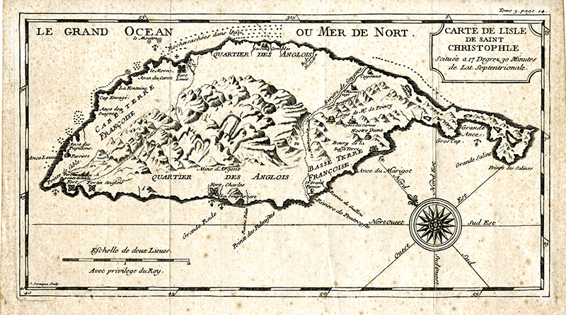
| Creator: | Sornique, Dominique (1708-1756) |
|---|---|
| Title: | Carte de lisle de Saint Christophle / J. Sornique sculp. |
| Publication: | France: 1742 |
| Description | 15 x 26.5 cm |
| Scale: | |
| Notes: | scan only |
| Shelf Mark: | VCSK/04 |
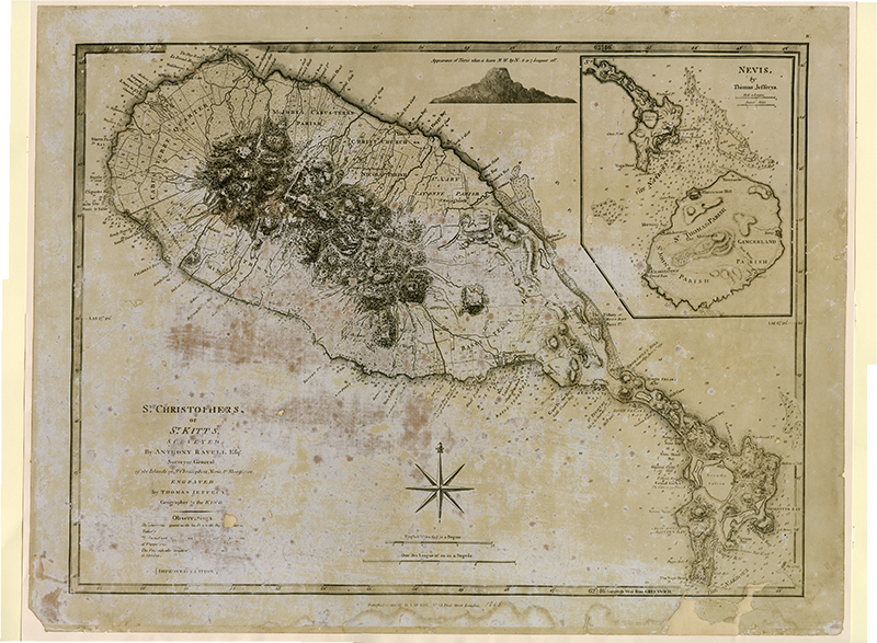
| Creator: | Anthony Ravell, Surveyor General Thomas Jefferys, engraver |
|---|---|
| Title: | St. Christophers, or St. Kitts, Surveyed by Anthony Ravell Esqr. Surveyor General of the ISlands of St. Christophers, Nevis and Montserat |
| Publication: | London by Richard H Laurie, Fleet Street. Improved edition 1865 |
| Description: | includes inset of Nevis. 47 x 62 cm |
| Scale: | 1 inch to app. 0.75 mile |
| Notes: | damaged |
| Shelf Mark: | VCSK/05 image not available |
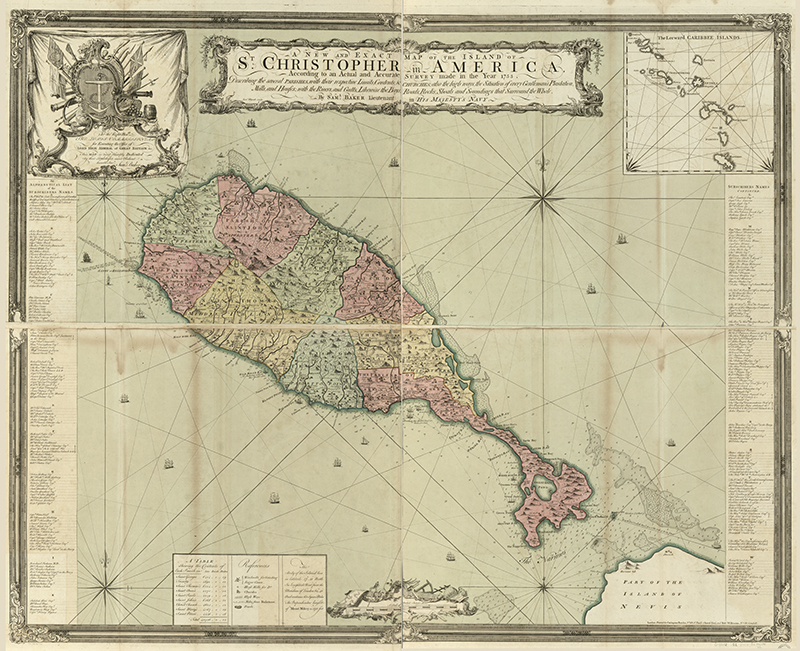
| Creator: | Lieutenant Samuel BAKER |
|---|---|
| Title: | A new and exact map of the island of St. Christopher in America, according to an actual and accurate survey made in the year 1753. Describing the several parishes, with their respective limits, contents, & churches; also the high ways, the situation of every gentleman’s plantation, mills, and houses; with the rivers, and gutts. Likewise the bays, roads, rocks, shoals and soundings that surround the whole. |
| Publication: | London, Printed for Carington Bowles and Robt. Wilkinson [1754] |
| Description: | 142 x 113 cm. |
| Scale: | 2inches to 1 mile |
| Notes: | shows plantation owners |
| Shelf Mark: | VCSK/ 06 - available as a photograph or scan only |
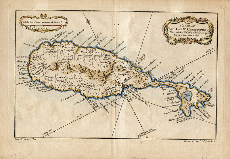
| Creator: | Jacques Nicolas BELLIN (1703-1772) |
|---|---|
| Title: | Carte de de [sic] l’Isle St. Christophe, pour servir à l’Histoire génle. des voyages. Par M. B., ingr. de la marine. |
| Publication: | Paris [1780] |
| Description: | 19.5 x 30.7 cm |
| Scale: | 1:78,000 |
| Notes: | Appears in Jean François de La Harpe's Abrégé de l'histoire générale des voyages ... Atlas. 1780. |
| Shelf Mark: | VCSK/07 |
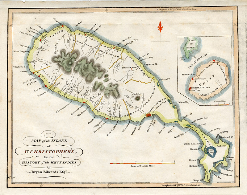
| Creator: | |
|---|---|
| Title: | Map of the Island of St. Christopher’s |
| Publication: | London: John Stockdale, 1794 |
| Description: | |
| Scale: | |
| Notes: | for the History ... of the British Colonies in the West Indies ... By Bryan Edwards, Esq |
| Shelf Mark: | VCSK/08 |
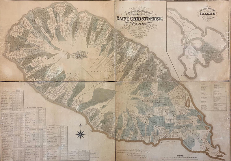
| Creator: | William McMAHON |
|---|---|
| Title: | A New Topographical Map of the Island of Saint Christopher in the West Indies decribing all plantations with their respective boundaries, the parishes, churches, towns, rivers, gutts, highways &c by William McMahon, surveyor of the island the whole accurately laid down in the year 1828 |
| Publication: | Edward Stanford, 26 & 27 Cockspur Street, Charing Cross, 1828 |
| Description: | 1 map on 4 sheets : 134.5 x 180 cm (dissected) |
| Scale: | [1:12 000] |
| Notes: | Inset: The South East part of the Island, on the same scale; 66 x 49 cm. Shows acreages of plantations; list of land-owners |
| Shelf Mark: | VCSK/09 |
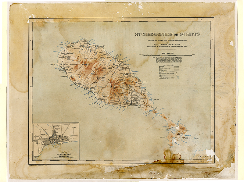
| Creator: | Major J. A. BURDON 1866-1933 |
|---|---|
| Title: | St. Christopher or St. Kitts |
| Publication: | London: War Office, 1920. |
| Description: | 17 x 21 in. |
| Scale: | 1:63,360 |
| Notes: | inset Plan of Basseterre. 4.5 x 5.5 in. |
| Shelf Mark: | VCSK/10 |
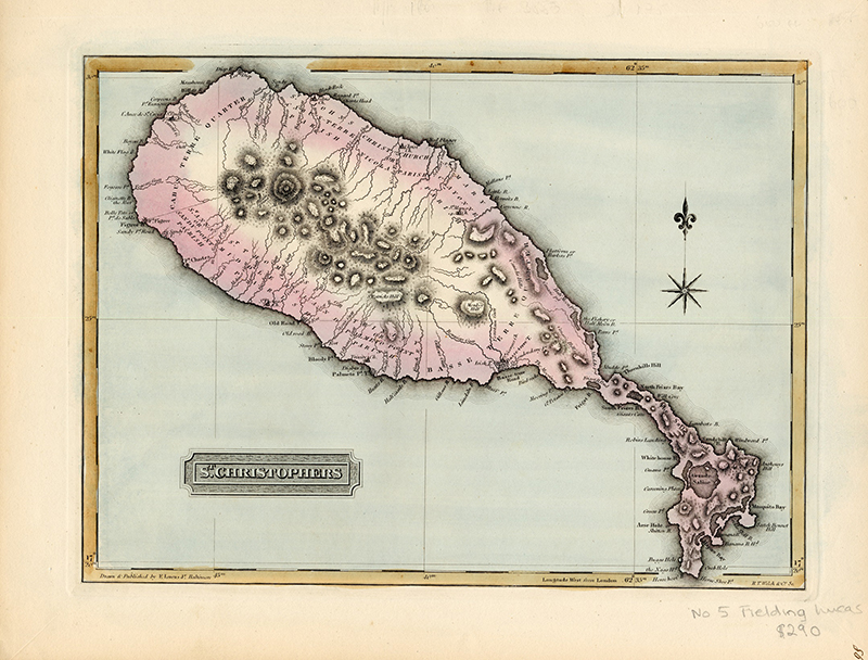
| Creator: | Fielding Lucas Jr |
|---|---|
| Title: | St. Christophers |
| Publication: | Baltimore, 1823 |
| Description: | coloured print, 22.2 cm x 30.5 cm |
| Scale: | 1: 40,39 |
| Notes: | published in A General Atlas Containing Distinct Maps Of all the Known Countries in the World, Constructed from the Latest Authority. Written and Engraved by Jos. Perkins, Philadelphia. Baltimore: Published by Fielding Lucas, Jun. No. 138, Market Street. Baltimore. Entered ... by F. Lucas Jr. of the State of Maryland June 3, 1823 |
| Shelf Mark: | VCSK/11 |
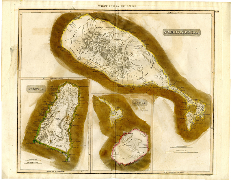
| Creator: | John THOMSON |
|---|---|
| Title: | St. Christopher, St Lucia, Nevis |
| Publication: | [1817] |
| Description: | 23 x 19.5 inches |
| Scale: | 1:70,000 |
| Notes: | Prepared for New General Atlas, Edinburgh, 1817 |
| Shelf Mark: | VCSK/12 |
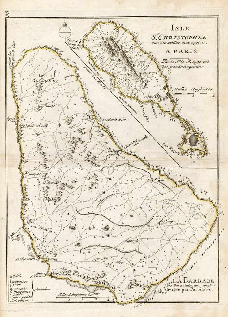
| Title: | La Barbade une des Antilles aux Anglois, divisée par paroisses |
|---|---|
| Publication: | Paris, Chez Crepy, 1767 |
| Description: | hand coloured: 27.2 x 20.2cm |
| Scale: | 1:110,000 |
| Notes: | Includes inset "Isle St. Christophle [sic] une des Antilles aux Anglois." |
| Shelf Mark: | VCSK/13 |
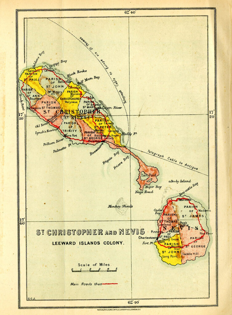
| Creator: | Waterlows and Son |
|---|---|
| Title: | St. Christopher and Nevis, Leeward Island Colony |
| Publication: | Waterlow and Son, London, [1911] |
| Description: | coloured print, 20cm x 13.2cm |
| Scale: | 1inch:4.25 miles |
| Notes: | shows parishes, main roads, underwater telegraph cables. |
| Shelf Mark: | VCSKN/01 |
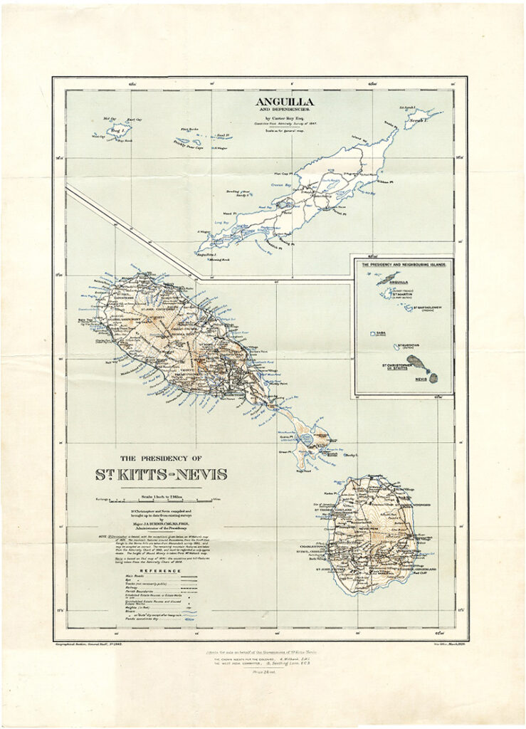
| Creator: | Major J. A. BURDON, administrator |
|---|---|
| Title: | The Presidency of St. Kitts-Nevi |
| Publication: | London: War Office, 1920. |
| Description: | 48.7 x 36 cm. |
| Scale: | 1 inch = 2 miles |
| Notes: | inset - Anguilla and Dependencies, Inset - Presidency and neighboring islands |
| Shelf Mark: | VCSKNA/01 |
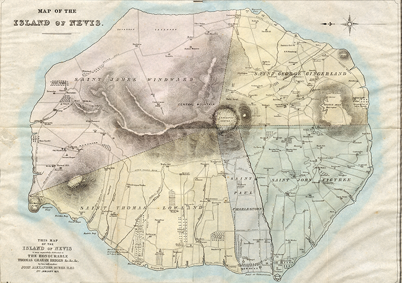
| Creator: | John Alexander BURKE ILES |
|---|---|
| Title: | Map of the Island of Nevis |
| Publication: | 2nd January, 1871 |
| Description: | |
Scale: | 3 miles to 1 inch |
| Notes: | "An account descriptive of the Island of Nevis, W.I." |
| Shelf Mark | VCN/01 |